


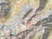


Triglav 1:25 000 map

9.10 €
7.28 €
(-20 %)
Price with cones if you have 1.82 cones
In stock
- Estimated date of dispatch:
today
The Triglav 1:25,000 map, published by Planinska zveza Slovenije (PZS), is a highly accurate topographic map designed for detailed exploration of the central part of the Julian Alps, with an emphasis on the Triglav mountain range and its surroundings. It is an essential tool for hikers, mountaineers and mountaineers venturing on trails in the Triglav National Park.
Features and Contents:
- Detailed scale 1:25,000: Allows for extremely precise orientation and display of terrain.
- Comprehensive overview of the area: Covers Triglav and the surrounding mountain range with all important peaks, valleys and passes.
- Marked hiking trails: Contains clearly marked hiking trails, often categorized according to difficulty (easy, difficult, very difficult).
- Mountain huts and bivouacs: The locations of all mountain huts and bivouacs are marked with relevant information.
- Natural and Cultural Attractions: Includes locations of key natural beauty and cultural landmarks.
- Contours and relief: Accurately displayed terrain with contours and shading.
- Coordinate grid for GPS: Often includes a rectangular (e.g. Gauss-Krüger) and geographic (WGS84) grid for easy use with GPS devices.
- Durable and long-lasting: Made from high-quality paper that is often tear- and water-resistant, and housed in a protective folder.
- Multilingual legend: Often contains a legend and additional information in Slovenian, English and German.
Publisher:
Planinska zveza Slovenije (PZS)
Ideal for:
Hikers, mountaineers and mountaineers who embark on tours in Triglav National Park, from easy walks to demanding high-altitude climbs, and for anyone who wants a detailed and reliable cartographic basis.
Characteristics
-
-
-
Scale- 1:25 000
| + Dodaj v košarico | www | LJ-BTC | LJ-Center | LJ-Rudnik | LJ-Šiška | Celje | Kranj | Novo mesto | Lesce | Maribor | Nova Gorica |
Similar products
Planinska zveza Slovenije

Planinska zveza Slovenije

Kompass

Sidarta

Sidarta
Planinska zveza Slovenije

Planinska zveza Slovenije

Planinska zveza Slovenije

Planinska zveza Slovenije
Planinska zveza Slovenije Hiking map Notranjska s Snežnikom 1: 50.000
9.10 €
Kompass Kompass 133 - Santiago de Compostella 1:100.000
9.99 €
Sidarta Map Bovec-Trenta 1:25 000
9.90 €
Sidarta Map Julian Alps 1:50 000
9.90 €
Planinska zveza Slovenije Map of Kamnik-Savinja Alps - 1:50.000
9.10 €
Planinska zveza Slovenije Mountain map Pohorje 1:50 000
9.10 €
Planinska zveza Slovenije Planinska zveza Slovenije Škofjeloško, Cerkljansko hribovje 1:50.000
9.10 €
